
Whiffle's Meso model simulates regional atmospheric conditions at kilometer scale, capturing how terrain, coastlines and weather systems influence wind and other weather variables. It provides the regional conditions driving Whiffle’s Large-Eddy Simulations (LES) and can also run independently for long-term regional studies.
Weather processes operate across different spatial scales. Global weather datasets describe large-scale atmospheric conditions, but regional features such as sea breezes, mountain winds and land–sea contrasts can significantly influence conditions at individual sites.
Whiffle’s Meso model represents these regional processes at kilometer-scale resolution, connecting large-scale weather data to the finer-scale flow simulated by Whiffle LES.
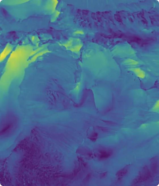
Whiffle's Meso model uses the same underlying physical principles as Whiffle LES, but represents turbulence through parameterizations rather than explicitly resolving turbulent eddies. This allows simulations to cover larger areas and longer periods.

Simulates weather features such as sea breezes, mountain and valley winds, and regional circulation patterns.

Represents how topography, coastlines and land-sea contrasts influence atmospheric conditions across a region.

Provides regional atmospheric conditions that can drive finer-scale LES simulations.
Whiffle's Meso model covers large geographic areas and extended periods, while still capturing regional atmospheric processes.

Horizontal grid resolution.

Regional domain size, depending on the case.

Simulation periods supporting long-term regional studies.
Explore a simulation of the Great Lakes using Whiffle’s Meso model, illustrating how atmospheric conditions develop and evolve across a region influenced by extensive water bodies and surrounding land.
See how wind conditions differ across a regional domain rather than assuming uniform conditions over large areas.

Follow how atmospheric conditions evolve as weather systems move and regional circulation patterns develop.

Explore how large water bodies and surrounding land influence regional wind patterns.
Whiffle's Meso model supports two different modeling approaches, depending on the spatial detail and simulation period required.
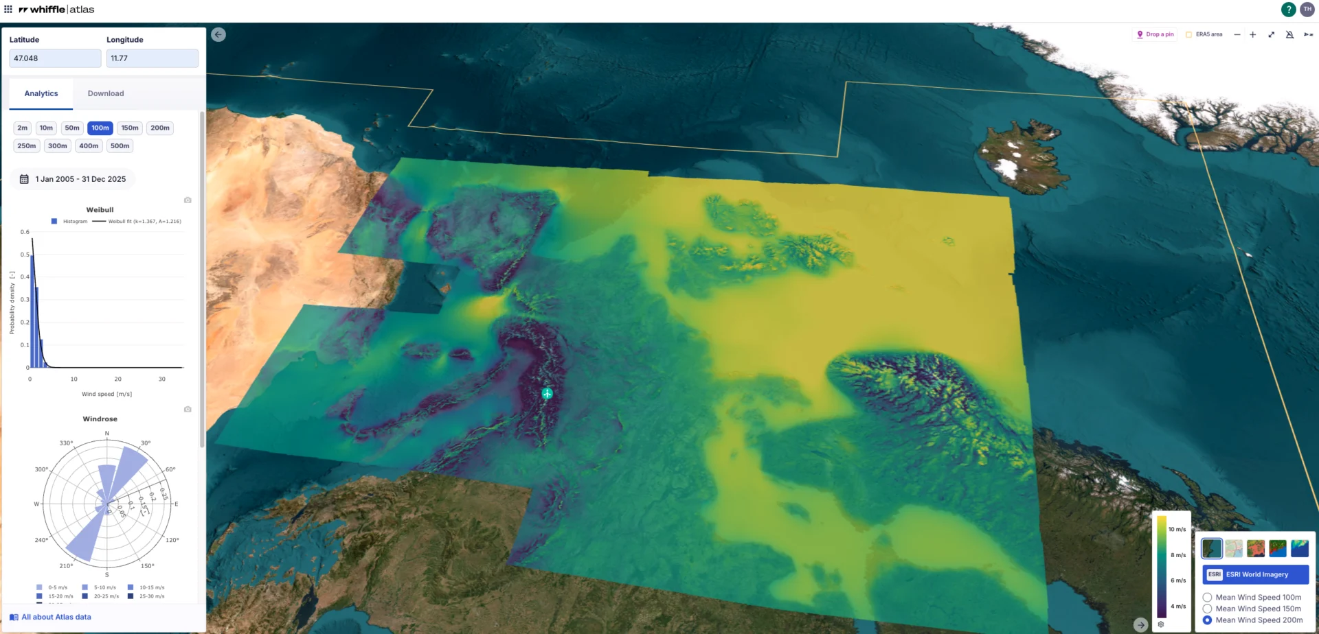
For applications where regional coverage and long-term wind conditions are the priority, Whiffle's Meso model can run independently. Its outputs support regional wind-resource studies and underpin the long-term wind datasets available through Whiffle Atlas.

Local wind conditions are influenced by weather processes extending far beyond an individual site. Whiffle's Meso model captures these regional influences and supplies boundary conditions for finer-scale LES simulations, where local flow and turbulence are resolved in greater detail.
In a benchmarking study conducted by RWE across 170 wind measurement sites, different modeling approaches were evaluated against observed wind conditions, from global reanalysis datasets to mesoscale and LES.
The study found that downscaling from reanalysis to mesoscale modeling delivered the largest improvement in wind-speed accuracy. Particularly offshore and over relatively simple terrain, mesoscale modeling already captured much of the relevant wind behavior, demonstrating its value for wind-resource assessment.
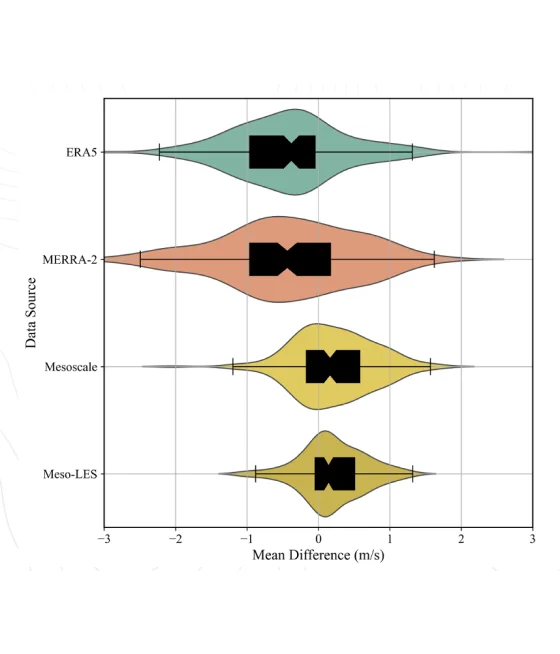
Figure: Distribution of mean wind-speed differences (m/s) across 170 sites for ERA5, MERRA-2, Mesoscale and Meso-LES.
Figure: Distribution of mean wind-speed differences (m/s) across 170 sites for ERA5, MERRA-2, Mesoscale and Meso-LES. (RWE Benchmark study)
Whiffle's Meso model simulates regional atmospheric processes at kilometer-scale resolution, representing smaller-scale turbulence through physical parameterizations. Whiffle LES operates at much finer resolution and explicitly resolves larger turbulent motions, providing greater detail on local atmospheric flow and turbulence.
Large-scale weather datasets may not capture regional influences such as coastlines and complex terrain in sufficient detail. Whiffle's Meso model represents these processes at kilometer-scale resolution and provides boundary conditions for LES, so finer-scale simulations account for the surrounding regional weather.
Whiffle's Meso model represents regional atmospheric conditions, including wind and the weather processes that influence it. The full range of available variables and outputs depends on the simulation configuration.
Whiffle Atlas provides access to precomputed long-term mesoscale wind data. For custom regional simulations or outputs, contact our team to discuss the available modeling options.
Whiffle Atlas, which uses Whiffle's Meso model, has been evaluated against wind measurements across 108 sites. The comparison found a mean wind speed bias of −0.09 m/s for Atlas, compared with −0.706 m/s for ERA5 at the same locations. Further information is available in our validation studies.
Tell us what you're modeling. We'll help you determine whether Meso, LES or a combination of both fits your application.
Meter-scale weather simulation for the sectors where weather drives decisions.
Peer-reviewed papers and technical reports
Articles and perspectives from our team
Conferences, webinars and on-demand recordings
Technical guides for the Whiffle platform
Get help from our team
Atmospheric science and Whiffle news in your inbox
Explore simulations from wind farms to city streets