Accurate WRGs for complex terrain, calibrated to your measurements.
Upload long-term corrected mast data. Whiffle Wind calibrates an LES-derived wind climate to your site.
Technology trusted by industry leaders


- 100 m resolution
- Calibration included (no extra cost)
- LES-derived
- Results in < 24h
Whiffle Wind generates wind resource grids from Large Eddy Simulation — resolving the actual flow physics of your site, not approximating them. Unlike conventional models that treat orography, forestry and land surface as correction factors, the Whiffle LES atmosphere interacts with your terrain directly, using real atmospheric data as boundary conditions. The result is a wind climate that reflects what your site actually does.
In complex terrain, your flow model
determines your accuracy.
Onshore wind is moving into complex terrain, where orography, forestry and atmospheric stability dominate the flow. Linear models approximate complex flow as correction factors – a structural limitation that’s in every grid cell before you’ve uploaded a measurement. CFD goes further, solving non-linear flow equations, but does not resolve the full turbulent regime.
Accurately representing the wind climate where terrain, thermal effects, canopy and atmospheric stability all interact simultaneously requires solving the complete equations including turbulence.
Whiffle LES does this directly, using ERA5 atmospheric data and high-resolution terrain, forestry and land use inputs. When you calibrate onto that baseline, your measurements are correcting a model that already resolved your site’s actual flow, not one that approximated it.
- Simple and moderate terrain
- Non-linear flow effects
- Flow separation at ridges and forest edges
- Full turbulent regime resolved
- Yes
- No
- No
- No
- Yes
- Yes
- Partial
- No
- Yes
- Yes
- Yes
- Yes
Swipe to compare →
- Simple and moderate terrain
- Non-linear flow effects
- Flow separation at ridges and forest edges
- Turbulence resolved
- Yes
- No
- No
- No
- Yes
- Yes
- Partial
- No
- Yes
- Yes
- Yes
- Yes
Up to 2.5x lower cross-prediction error in complex forested terrain
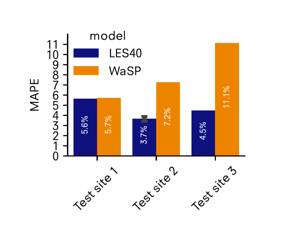
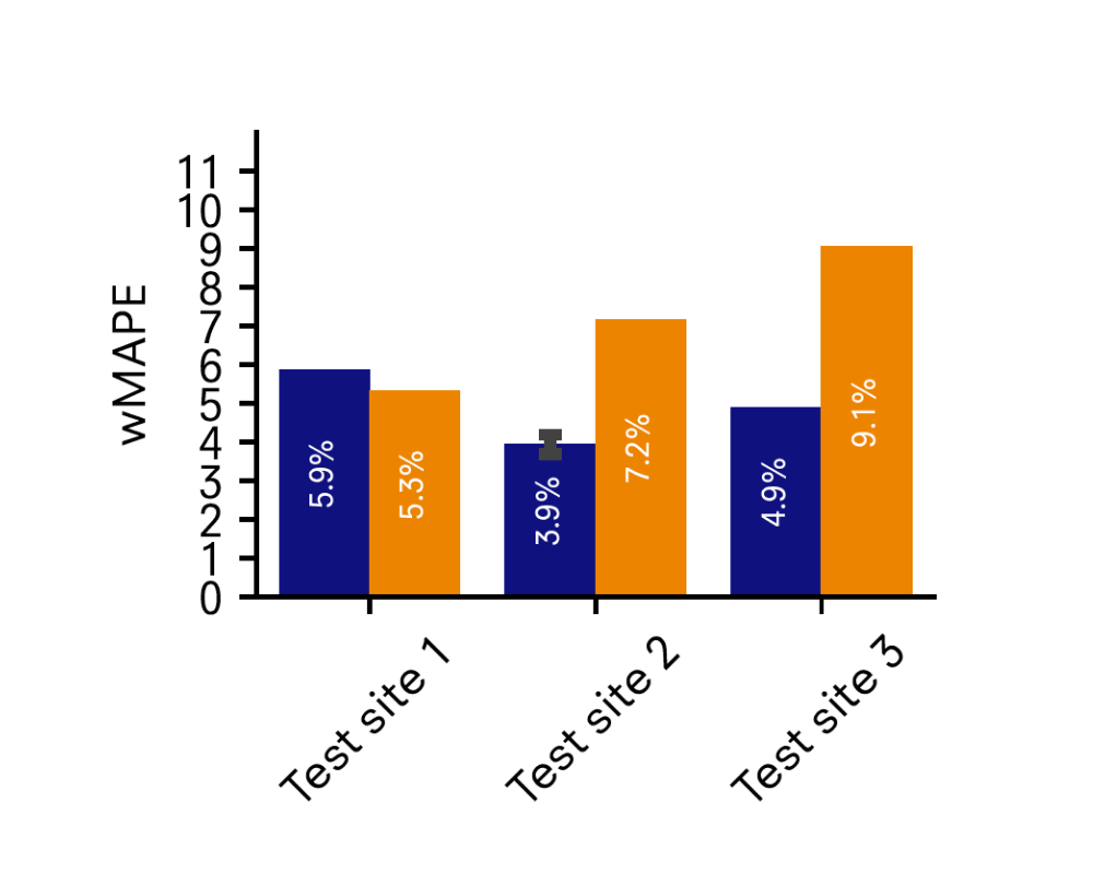
Forests are one of the most persistent challenges in wind resource assessment. Flow through complex, heterogeneous canopies is non-linear, scale-dependent, and changes over a project’s lifetime.
In a joint project with Perigus Energy, presented at WindEurope, Whiffle tested LES model performance across three complex forested sites in the UK and Ireland. Each model was calibrated using one mast and tested on its ability to predict wind speed at all other locations on site, per wind sector. Cross-prediction MAPE: Whiffle LES 3.7%, linear flow model 5.6–11.1% on the same sites.

"A major step forward in long-term wind modelling"
“Accurately characterising wind conditions is one of the most critical and challenging aspects of onshore project development, particularly in complex forested terrain. Whiffle Wind is built on Whiffle’s atmospheric LES model, resolving the physical processes that determine the wind field at these sites: canopy drag, atmospheric stability, thermally driven flows. Through our joint development work, it has become a core part of how we improve confidence in wind resource assessments for our most challenging onshore sites”
Andrew Davidson, Senior Wind Energy Analyst at Perigus Energy
Pricing
Pricing is based on domain size and simulation period. For larger domains or bespoke project requirements, contact support@whiffle.nl.
| Domain size* | 20-year Statistics run | Calibration |
|---|---|---|
| Small (12.8 km × 12.8 km) | € 493 | ✓ Included |
| Medium (51.2 km × 51.2 km) | € 3,131 | ✓ Included |
| Large (102.4 km × 102.4 km) | € 7,890 | ✓ Included |
Swipe to see →
See it on a site like yours — then run it yourself.
Book a 30-minute demo and we’ll walk through how you can get the most out of Whiffle Wind for what you need — how to set up simulations, interpret your outputs, and fit it into your existing workflow. You’ll leave with free credits to run your own simulations.
Do you need 10-minute resolution?
When your yield assessment requires a full time series — for detailed AEP modelling, P50/P90 analysis at 10-minute resolution, or wake modelling inputs — a Whiffle Wind time series is the natural next step.
Frequently Asked Questions
Getting started
I don’t currently use Whiffle Wind. Can I still run a calibrated WRG?
Yes. The demo is the starting point. Book a 30-minute session and we’ll walk through a calibrated WRG for a site in your region. You’ll leave with free credits to run your own.
How long does it take to get a calibrated WRG?
Typically within 6–24 hours from uploading your measurements, the same turnaround as a standard statistics run. No additional setup time, no separate workflow.
Does calibration cost extra?
No. Calibration is included in every statistics run at no additional charge. The cost is based on LES domain size and simulation period — the same as a standard run.
Your data and workflow
What measurement data do I need to upload?
Long-term corrected wind speed and direction at 10-minute end-of-interval timestamps in UTC. NaN values for missing or erroneous data points. Met mast and lidar both accepted — if you have wind speed and direction at matched heights, it works. A template is available in the upload form.
How many masts do I need?
One mast is sufficient. Multiple locations are supported — each additional mast improves the spatial coverage of the correction across the grid. Read the documentation for more detail.
Can I edit my measurements after the simulation is complete?
No. Measurements must be marked as final before use in a simulation and cannot be edited after that.
How it works
How is this different from applying corrections in WindPRO or OpenWIND?
The method is the same — spatially distributed, inverse-distance-squared weighting from mast locations. What changes is the model you’re calibrating onto. Correcting an LES-derived WRG that already resolves terrain physics, non-linear flow effects and flow separation at 100m resolution produces a better result than correcting a linearised flow model. Same method, better baseline.
Is calibration available for time series
Calibration is available for statistics runs only. You can request a calibrated time series by setting up a simulation in Whiffle Wind and selecting Run via support on the Overview step. In the information field, indicate that you would like a calibrated time series. Alternatively, you can contact support@whiffle.nl to discuss options.