Whiffle Atlas
Instant access to long-term mesoscale data with a near-zero bias and narrow error spread.
Long-term mesoscale data you can trust, for
MCP and site-screening
Standard long-term datasets can miss key local effects, especially in coastal, nearshore, or complex terrain. This increases uncertainty in MCP and early-stage assessments.
- 20-year time series
- Hourly-averaged
- 2 km resolution
- 10 heights
- 15 variables
- Instant
Whiffle Atlas addresses that gap with instant access to long-term validated wind data you can trust. You get 20 years of hourly time series at 2 km resolution and 10 fixed heights (up to 500 m), benchmarked against hundreds of measurements. The result: stronger mast correlations, reduced long-term correction uncertainty, and more confident project screening.
Whiffle Atlas is currently available for Europe, US, Australia, Korea, Japan. More regions are in development and available upon request.
Accuracy matters, especially
when you're long-term correcting
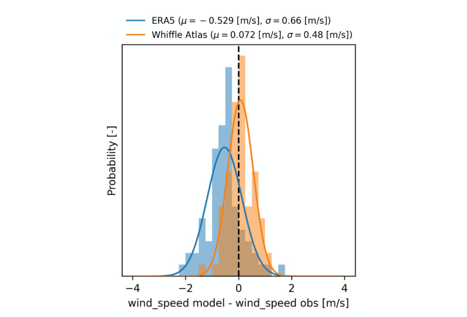
From MCP to yield estimates, the uncertainty of every step depends on the accuracy of your long-term reference. That’s why the Whiffle Meso model behind our Atlas has been rigorously benchmarked against over 300 met masts across 170 sites globally – including onshore, offshore, and complex terrain.
Across these validation campaigns results show:
- a mean wind speed bias of 0.07 m/s
- standard deviation of 0.48 m/s.
This narrow error spread strengthens confidence in long-term correction, minimizes MCP uncertainty, and enables more reliable early-stage decisions.
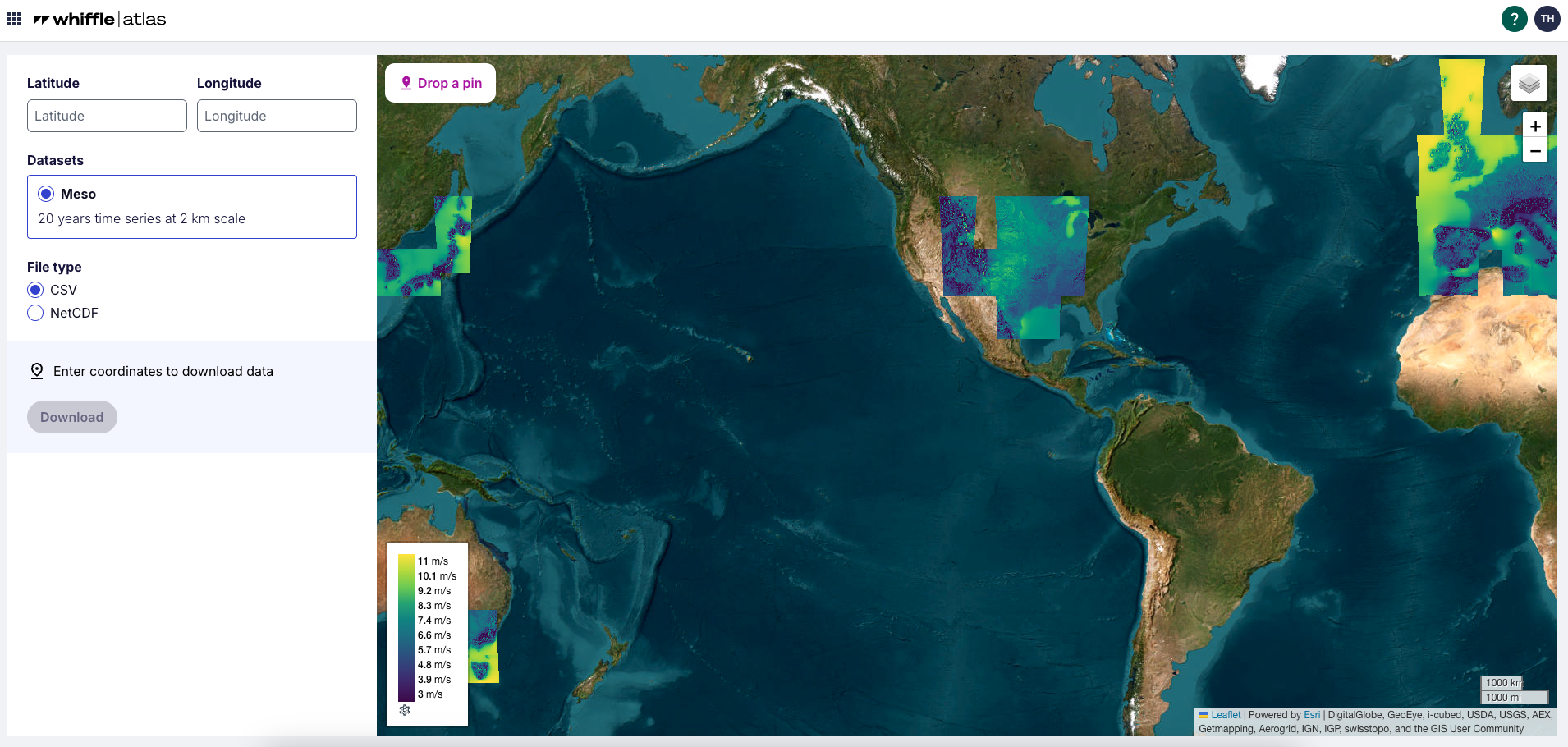
Drop a pin, get your data in seconds
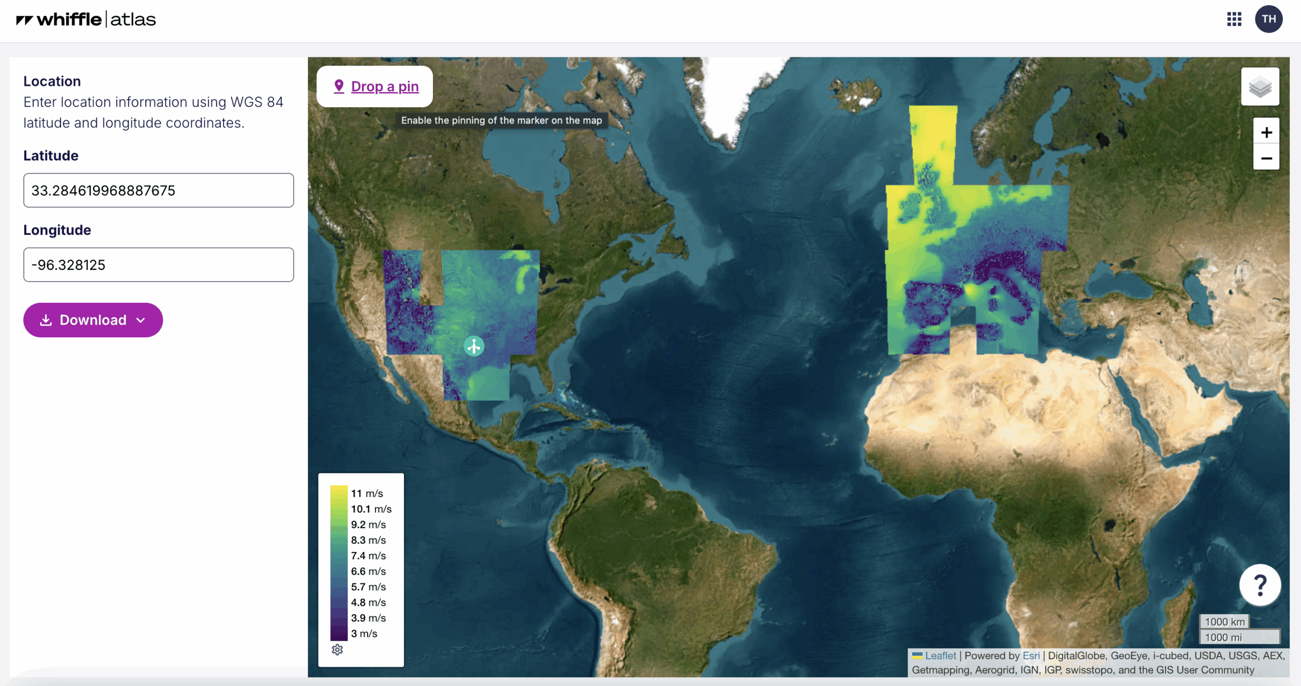
How it works:
- Pick your location - Drop a pin or enter coordinates
- Download instantly - You'll receive a precomputed, 20-year, hourly time series in .csv or .netcdf format.
- OR access via API - Whiffle Atlas is available programmatically through our REST API, with an official Python SDK for developers.
Pricing
Whiffle Atlas offers transparent pricing, with bundled discounts available. Start with a free trial.
Free trial
- Validate on your own sites before you commit
- Includes 5 free mesoscale downloads (your choice of locations)
- Instant downloads - outputs ready in seconds
Per-site lookup
- €450 per download
- Instant downloads - outputs ready in seconds
- Ideal for ad-hoc or one-off site assessments
Discount
- Discounted tile packs and flat-rate regional access
- Custom pricing for large portfolios
- Ideal for consultants and developers working across markets
Features
| Parameter | Details |
|---|---|
| Spatial resolution | 2 km × 2 km |
| Temporal coverage | 20 years (hourly) |
| Vertical levels | 2m, 10m, 50m, 100m, 150m, 200m, 250m, 300m, 400m, 500m |
| Variables | wind speed, wind direction, vertical velocity, air density, pressure, surface pressure, temperature, surface temperature, relative humidity, boundary layer height, turbulence kinetic energy, Brunt-Väisälä frequency squared, vertical shear squared, Richardson number, inverse Obukhov length. |
| Geographic coverage | Europe, US, Australia, Korea, Japan. More regions in development and available upon request. |
| Data formats | CSV, NetCDF |
| Integrations | WindPRO, OpenWind and other standard tools. API access available. |
| Coming soon | Turbulence intensity (TI) proxy, key statistical metrics, WRG output and additional regions. |
Stay updated
We’re continuously expanding Atlas. Subscribe to The Eddy Effect (our monthly newsletter) and be the first to hear about product updates.
Frequently Asked Questions
What is Whiffle Atlas?
Whiffle Atlas is a validated, precomputed, mesoscale dataset offering 20-year hourly wind time series at 2 km resolution across 10 heights (2–500 m). Built for MCP workflows and early-stage screening, it’s instantly downloadable and available today for Europe, the US, Australia, Japan, and Korea.
What is the horizontal and vertical resolution?
- Horizontal: 2km × 2 km grid
- Vertical: depends on the location, but comes down to 50 m (fixed) between ground level and highest point in the region, which stretches +5% every grid point above the highest point.
How is Whiffle Atlas different from ERA5, GWA, or other mesoscale datasets?
Whiffle Atlas provides finer spatial resolution (2 km) and more height granularity (10 fixed levels from 2 to 500 m) than ERA5 or GWA, making it more representative at project scale. Unlike raw reanalysis, Atlas is precomputed, directly downloadable, and validated against over 300 met masts globally.
What sets Atlas apart is its performance in MCP use cases: across validation campaigns, it shows lower wind speed bias and higher correlation to measurements than other mesoscale datasets. That means reduced uncertainty in long-term wind estimates, especially in nearshore zones, coastal areas, and complex terrain where global models tend to underperform.
Use Atlas as an additional reference alongside ERA5, or as a faster, portfolio-scalable alternative to traditional on-demand mesoscale simulations.
What’s included per Atlas download?
Meteorological variables include: wind speed, wind direction, vertical velocity, air density, pressure, surface pressure, temperature, surface temperature, relative humidity, boundary layer height, turbulence kinetic energy, Brunt-Väisälä frequency squared, vertical shear squared, Richardson number, inverse Obukhov length.
What is the Whiffle Meso model?
The Whiffle Meso model is Whiffle’s in-house mesoscale weather model, developed alongside its LES model. Like LES, it is a physics-based numerical model but it operates at a coarser horizontal resolution of 2 km. While it does not resolve turbulence directly (as turbulence is typically smaller than 1 km), it uses physical parametrisations to capture the net effects of turbulence on atmospheric flow.
This makes the Whiffle Meso model well-suited to resolve larger-scale phenomena like coastal transitions, regional wind gradients, and sea breezes. It is used both as a pre-driver for LES simulations and as a standalone engine for generating long-term wind climatologies – as in Whiffle Atlas. This allows for cost-effective coverage of large spatial domains and multi-decade timeframes.
What do I get with my Whiffle Atlas free trial?
Five site lookups: 20-year, hourly wind datasets at 10 heights for any location in the available regions. No credit card, no setup required.
How is pricing structured?
You can start for free, no credit card required. Every user gets 5 free dataset downloads to test Whiffle Atlas on their own sites.
After that, access is simple and scalable:
€450 per site download
Discounted rates available for bulk lookups, regional coverage, or portfolio subscriptions
Whether you need data for one project or dozens, there’s a plan that fits.
Can I access the data programmatically?
Yes, via the Whiffle Python client: whiffle-client on PyPI.
Is Atlas output raw LES output?
No. Atlas is based on the Whiffle Meso model (mesoscale). For raw LES at 100 m resolution, use Whiffle Wind.
Can I preview the dataset before downloading it?
Not yet, but this feature is planned to be released soon.
How do i start a Whiffle Atlas free trial?
You can get started with creating your account, by filling in this form.